Forks of the Credit Provincial Park
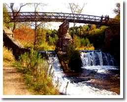
Forks of the Credit is on the famous Bruce Trail. The park features the excitement of the Credit River, as it narrows and rushes through a deep gorge, plunging over a falls. Geological features that were deposited or carved out by retreating glaciers, such as kame hills and kettle lakes, surround the river. The park also includes some of the upland, rolling pasture land that is typical of much of southern Ontario.
| Name | Forks of the Credit Provincial Park |
| Description | Enjoy six hiking trails that lead you to Kettle Lake, the Credit River, great open spaces and the scenic beauty of the falls. Biking and fishing are permitted but hunting is forbidden. Hiking and picnicking are favourite activities here. |
| Activities | Hiking, walking, biking, cross country skiing, snowshoeing, and horse back riding. |
| Location | Forks of the Credit Provincial Park is located at 17802 McLaren Road, south of Hwy. 124 about 24 kilometres northwest of Brampton between Brimstone and Cataract. Take Charleston Sideroad from Caledon, then go south on McLaren Road. |
| Maps | Forks of the Credit Trail Map |
| Parking | Parking lot ($11.00 a car). |
| Trail Head | Various trail sections |
| Trail End | Various trail sections |
| Distance | 6.2 km |
| Difficulty | Easy to moderate |
| Surfaces | Natural |
| Amenities | Washrooms, picnic tables, marked trails, and viewing platforms. |
| Landmarks | Credit River, mature forest and waterfall. |
| Cost | No cost |
| Trail Web Site | Forks of the Credit Walk and Roll Peel |
| Closest Town | Belfountain |
 Headwaters Communities in Action


